Developing port infrastructures and protecting natural heritage in Veracruz (Mexico)
By Loïc MÉNANTEAU et Stephan GAILLARD
L’Atlas Bleu / Protecting
Bathymetry, sediment budget, port, environment, national park, Gallega (La), Veracruz, Vergara (Bay of).
This article presents the main development stages of the port of Veracruz (Mexico), an historic site located on the edge of a protected reef system. A digital terrain model (DTM) allows to follow its transformation (embankments on the sea, dredging, infrastructures) on three dates (1886, 1911, 2010), mainly since the big works leaded from 1887 to 1902. Finally, the environmental impacts on the reef system due to port of Veracruz expansion in Vergara Bay are discussed.

The port site of Veracruz: context and evolution since the 18th century

As Mexico’s main port, between 1564 and 1776 Veracruz played a major role, ensuring a monopoly on trade between Spain and the Viceroyalty of New Spain.


By major infrastructural work between 1887 and 1902, the layout of the port’s original site was completely overhauled: the former natural access channel to the port, the Canal del Norte, was closed off by a sea wall and artificial boundaries were created around the port area by constructing embankments (e.g. Malecón) in front of the former shoreline (220 ha approx.), causing the coral reefs to calcify (e.g. La Caleta). In 2004, platforms were built on the south of La Gallega reef and the external part of the northern sea wall to accommodate containers and industrial activity.
Bathymetry and sedimentary studies
A study of how the site evolved between 1886 and 2010 was made after digitising bathymetry data (x,y,z), the outlines of plans from 1886 and 1911 and nautical charts from 2010. From a sedimentary perspective, the Canal del Norte was backfilled after the seabed was deepened (average 1 m) and levelled out during the initial works (1887-1902). Then, in 2004-2006, the bed was deepened further (average 2.5 m), which affected the underwater cultural heritage (many incidences of damage recorded), particularly in the former channel.

DTM of the port of Veracruz on three dates.
1886: two major morphological factors: (1) Canal del Norte (NW- SE), average depth = 8-10 m, max. = 11-15 m; (2) Coral reef with, in the north, La Gallega protecting the site from northerly swell and winds.
1911: the water area is reduced; the seabed is deepened and evened out (the Canal del Norte is backfilled and its borders over-deepened, reefs are removed).
2010: the water area is reduced more significantly; the southern part of La Gallega and the external part of the north-west embankments are backfilled; the seabed is lowered (1911-2010: from 7.1 to 9.6m); the access channel is dredged (depth =13-15 m).
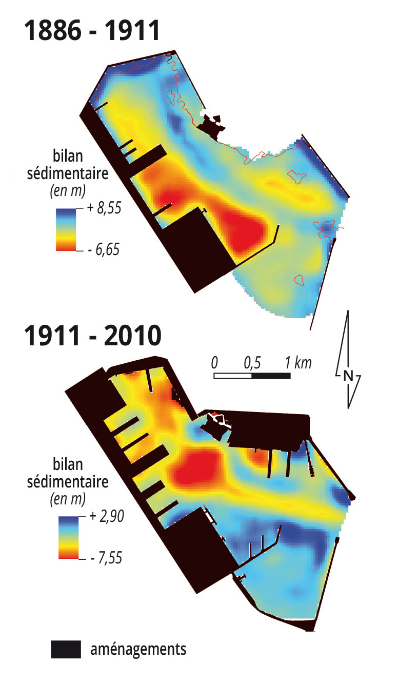
Changes to the seabed in approximate averages
1886-1911: deepening works carried out on the edge of platforms and jetties, the depth of the former Canal del Norte is reduced.
1911-2010: a deeper access channel is built, a turning basin (central zone in red) is developed, reduction of depths south of the port entrance.
Processing: Stéphan Gaillard
Port facilities and environmental protection measures

Port expansion works (area: 910 ha; backfill volume: 38 million m3; annual cargo capacity to increase from 21 Mt to 128 Mt in 2030) in Vergara bay (which began on 24-11-2014) have provoked conflict between environmental conservationists and developers.
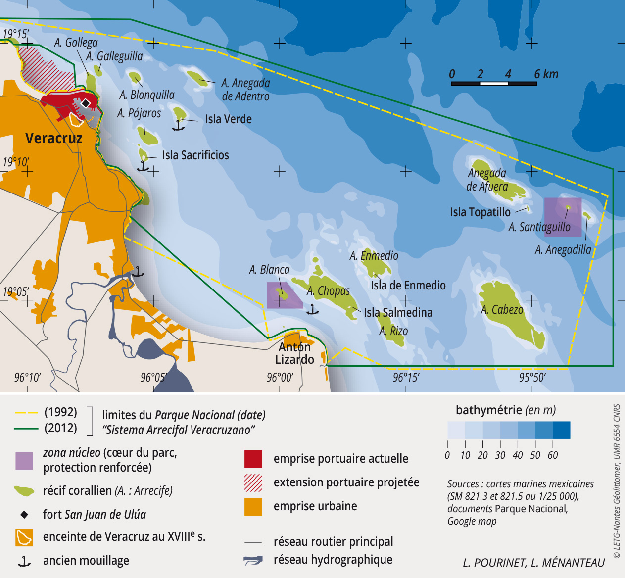
The site of the port of Veracruz is surrounded by a coral reef system made up of 23 coral reefs and six islets, divided into two groups. The reef system has been declared a national marine park (1992), a national park (2000), a Ramsar site (2000) and a MAB reserve (2006). As Mexico’s main port, between 1564 and 1776 Veracruz played a major role, ensuring a monopoly on trade between Spain and the Viceroyalty of New Spain.
Although, in 2012, the surface area of the National Park was increased by 132.78 km2 (from 522.38 km2 to 655.16 km2), i.e. 25.4 %, Vergara bay and part of Punta Gorda reef were excluded from the new zone to make the port expansion possible. To address risks in the future, integrated management will be essential to safeguard the reef system, which has already suffered serious deterioration.
VERAPORT Franco-Mexican project – CNRS / CONACYT (2011-2013)


Leave A Comment