
Deconstructing marine maps: revealing map-making choices through fishing and pleasure boating
Deconstructing marine maps: revealing map-making choices through fishing and pleasure boating By Juliette DAVRET L'Atlas Bleu / Exploring geotechnologies, cartography, critical GIS, fishing, pleasure boating, spatio-temporal variability Critical cartography has shown that maps are not neutral, yet they are a decision-making tool. This article uses the case study of fishing and pleasure boating to explore possible map-making choices. These two distinct marine activities, which are complex to map because of their spatio-temporal variability, provide an opportunity to address a wide range of cartographic issues. Data exist to describe fishing, but

The Banco Chinchorro
Banco Chinchorro (Caribbean Sea, Mexico): underwater cultural heritage and environmental protection By Laura CARRILLO MÁRQUEZ and Loïc MÉNANTEAU L'Atlas Bleu / Protecting Atoll, natural site, shipwrecks, integrated management, Caribbean Sea, Mexico. The case of Banco Chinchorro (Mexico) illustrates the problems of the protection and management of maritime sites boasting a natural and cultural heritage. The biodiversity of this atoll justifies its environmental protection at national and international level and yet, its underwater archaeological heritage has been excluded. We discuss the importance of integrating nature and culture in a single management plan

Cyclones and earthquakes
Cyclones and earthquakes By Riwan KERGUILLEC et Dominique SELLIER L'Atlas Bleu / Exploring cyclone, earthquake, oceanic fronts, vulnerability The article highlights the physical characteristics and formation mechanisms of tropical cyclones and earthquakes on a global scale. Two maps provide visualization of the concentration zones for each of these phenomena and demonstrate the very high level of exposure of the planet’s oceanic fronts. Tropical cyclones are large-scale seasonal weather phenomena (gusts of up to 118 km/h) that count as one of the hazards

Maritime safety in the Channel and the Bay of Biscay and the loss of merchant ships
Maritime safety in the Channel and the Bay of Biscay and the loss of merchant ships By Éric LE GENTIL L'Atlas Bleu / Preventing Maritime traffic, security, prevention, merchant ship, Channel and Bay of Biscay. The article presents an inventory and a typology of the means used to fight against the shipping accidents in the English Channel and the Bay of Biscay, two important places of the global maritime traffic. A map summarizes the spatial articulation of the system set up both at sea and on land. The documents look at

Tsunami vulnerability assessment for Wallis and Futuna and protecting populated areas
Based on the physical characteristics of the Wallis and Futuna Islands, this article expose the risk factors of each islands according to the exposure of the populations and proposes a synthetic zoning map of their territories according to the degree of global vulnerability. The solutions emanating from the local authorities to alert the inhabited areas are visuealized and compared.
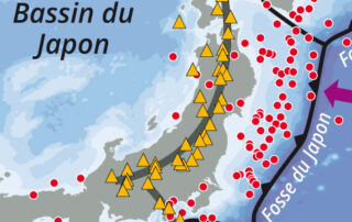
Japan: an example of an archipelago at high seismic risk
Japan: an example of an archipelago at high seismic risk By Jacques Guillaume L'Atlas Bleu / Preventing Earthquake, tsunami, population, deadly disaster, Japanese archipelago. This article presents a cartography of the main structural elements placing Japan in an intense seismic zone. It compares the population density of the archipelago with the inventory of earthquakes which occur over the 20th century. These elements show the vulnerability of this area. The example of the earthquake of march 11, 2011, reminds the chain of catastrophic events that led to the major nuclear accident in

Extreme sea levels on the Atlantic coastline in France: model and observations
Extreme sea levels on the Atlantic coastline in France: model and observations By Etienne CHAUVEAU L'Atlas Bleu / Exploring Extreme sea levels, models and measurements, recent period, Atlantic coast of mainland France. The article identifies the 10 most important storms in terms of marine submersion that have occurred on the Atlantic coasts of mainland France since 1984. It indicates the maximum sea levels recorded during these events. These values are compared with the extreme sea levels (with a 100 years period) derived from the SHOM/CETMEF predictive model. Several observations are drawn

The El Niño phenomenon: a model of global ocean disruption
The El Niño phenomenon: a model of global ocean disruption By Jean-René VANNEY L'Atlas Bleu / Exploring El Niño, climatic disruption, oceanic phenomenon, devastating effect, South America. With two maps and a graph, the article summarizes the principle of El Niño – a climatic disruption whose geographical amplitude and environmental implication are major at a world scale. The sequence of the phenomenon (whose frequency remains poorly known), that occurred in 1982-1983 on the coasts and off the coast of South America, is mapped and analysed specifically.

Piracy worldwide and its recent developments (1985-2012). The case of Africa
Piracy worldwide and its recent developments (1985-2012). The case of Africa By François GUIZIOU et Daenis OTSA'A NGUEMA L'Atlas Bleu / Preventing Maritime piracy, evolution, spatial characteristic, Gulf of Guinea, Gulf of Aden, Africa Through maps and graphs, the article presents the world geographical context of maritime piracy and its recent evolution. Maritime piracy has been geographically refocused on the African “shores”. Then, it examines in details the piracy occurred on the coasts and seas of the African zones concerned by this phenomenon (Gulf of Guinea and Gulf of Aden), by
Distribution of major naval forces worldwide
Distribution of major naval forces worldwide By Jacques GUILLAUME L'Atlas Bleu / Preventing Naval force, strategic base, ranking of States, world In this article, the inventory and spatial distribution of the strategic bases of the world’s main naval forces and the ranking of the top 15 oceanic military powers provide insights into the strategies of the States in terms of political influence on the blue planet. Spatial distribution of the strategic bases of the world’s main naval forces (interactive map)