Natural marine and coastal risks worldwide
By Dominique SELLIER and Riwan KERGUILLEC
L’Atlas Bleu / Exploring
Maritime facade, natural risk, main driver, exposure factor, synthesis scheme, spatial differentiation.
What are the major naturals risks facing the maritime facades at the scale of the planet, and what are they main drivers? The aim of this article is to propose a synthetic analysis of the different types of risks that make maritime facades particularly exposed, and to map the different coastal and maritime areas.
Marine and coastal risks are geographically linked to coastal fronts and thus, to interaction phenomena. From a physical point of view, coastal fronts are coastal-centric areas characterised by discontinuities and flows. These flows are influenced by the movement of tectonic plates, ocean circulation, atmospheric circulation and transfers linked to estuaries. They are subject to disruptions when certain thresholds are exceeded. On the whole, coastal fronts comprise a whole range of attractive environments, offering the possibility of access to resources from several contrasting environments. Coastal fronts are therefore high-risk areas. These risks come from the direct or combined effects of tectonic, oceanic and climatic factors.
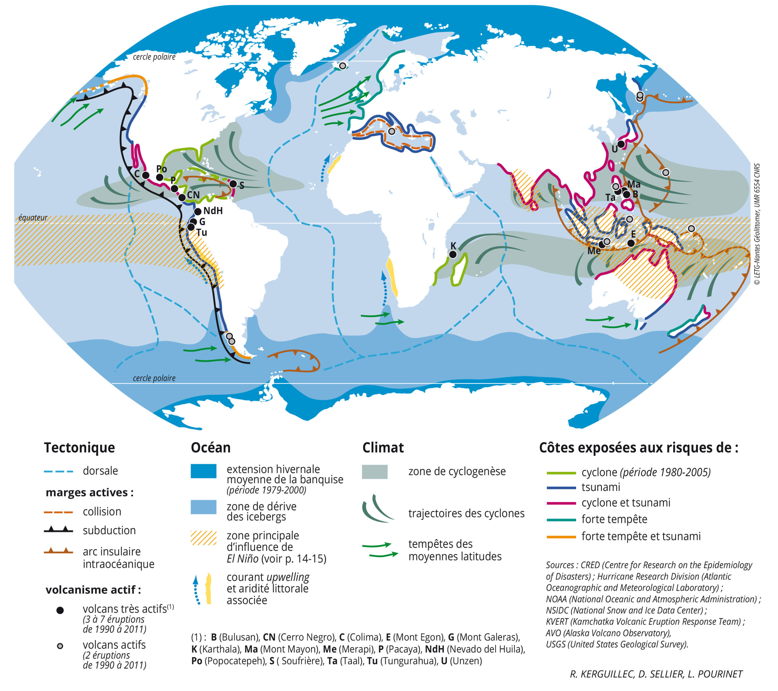
They also depend on the orientation of fronts and zonation. Tectonic risks are linked to the different types of lithospheric plate boundary. The first type concerns oceanic islands, associated with ridges (Iceland, the Azores) and hotspots (Hawaii), where volcanism is effusive in most cases. Active margins subjected to convergent plate dynamics are higher risk areas. Margins where plates collide are, by nature, rarely located near seas, except in the case of the Mediterranean basin, where volcanism is localised, yet active (Etna), and earthquakes are destructive. Subduction margins are areas with high seismic activity and where volcanism is explosive in most cases. The eastern coasts of the Pacific Ocean are concerned by these margins. The intra-oceanic island arcs running from the Bering Sea to New Zealand are even more unstable due to a combination of risks, both tectonic and oceanic (tsunamis). The other marine and coastal risks are associated with oceanic hydrology and the climate, along with their fluctuations, to varying degrees.

They fall into one of three categories. The first consists of purely oceanic risks: heavy swells, large tidal ranges and eustatism, which dictate coastal erosion over different time periods; and currents, whose trajectories lead to specific types of coastal aridity and whose instability reinforces biological imbalances brought about by seas or coasts. The second comprises risks arising from the effects of the weather at the surface of the oceans, some permanent (frozen seas), some seasonal (tropical cyclones) and some sporadic (coastal submersion). The third consists of risks often caused by storms that sometimes damage coastal areas in temperate climes. As a result, coastal fronts are exposed to risks in different ways depending on their orientation and their latitude, with Pacific and Indian Ocean coastal fronts renowned for being the most at threat. Discrepancies between the intensity of the physical phenomena and the extent of the material and human damage caused make it difficult to assess the risks. Natural hazards are heterogeneous; they are the result of both structural and zonal factors. The risks are measured in terms of costs and losses; they depend on the distribution of populations and their economic status.


Leave A Comment