Tsunami vulnerability assessment for Wallis and Futuna and protecting populated areas
By Sigrid GIFFON
L’Atlas Bleu / Protecting
Wallis and Futuna Islands, tsunami risk, aggravating physical and human factors, vulnerable sectors, prevention of inhabited areas.
Based on the physical characteristics of the Wallis and Futuna Islands, this article expose the risk factors of each islands according to the exposure of the populations and proposes a synthetic zoning map of their territories according to the degree of global vulnerability. The solutions emanating from the local authorities to alert the inhabited areas are visuealized and compared.

Wallis and Futuna, a French overseas territory in the South Pacific, has two main islands: Wallis, with a population of approximately 9000 people, and Futuna, with a population of approximately 4000 (INSEE-STSEE, 2013). Wallis (7 x 14 km) is a low-lying and fairly flat island, while Futuna (6 x 12 km) is higher, with steep slopes and hilly terrain. Wallis has a lagoon and unbroken coral reef flats whereas there are no lagoons or coral reef flats around Futuna. The archipelago is vulnerable to tsunamis. Recurring alerts have prompted the local authorities to take measures to identify areas at risk and improve systems for warning the population.
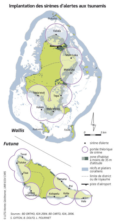
Human and physical factors that could either aggravate or reduce the risk (see opposite) have been defined specifically for these islands to create a map of risk zones in the event of a tsunami. The map produced shows that almost 74% of the surface area of Wallis is located in an area at risk from tsunamis, compared with just 17% of the surface area of Futuna. However, Futuna, which is less populated than Wallis, appears to be more vulnerable than its sister island due to the location and configuration of its settlements: 95% of buildings on Futuna are located in risk zones, compared with 87% of buildings on Wallis. Futuna’s population is primarily distributed along a narrow coastal strip of 100 to 300 metres (see photo of the village of Kolia in the south-east of Futuna). Furthermore, there are no geographical features (e.g. coral reef flats, islets, lagoons or mangroves) to reduce the risk on Futuna, which makes the island particularly vulnerable to the impact of tsunamis (in addition to a major risk of earthquakes). The local authorities (prefecture and customary authorities) have taken the tsunami risk seriously and installed 16 warning sirens (with a theoretical range of 2 km): nine on Futuna and seven on Wallis. They therefore clearly recognise that Futuna would be more vulnerable than Wallis in the event of a tsunami, as although it is only half as populated as Wallis, more sirens have been installed there.

Kolia village (Futuna), 2006 (Photo: S. Giffon).
Oblique aerial view. The village, on a narrow coastal strip (with no coral flats for protection), has few upland escape areas, because of the mountainous and thickly wooded slopes.
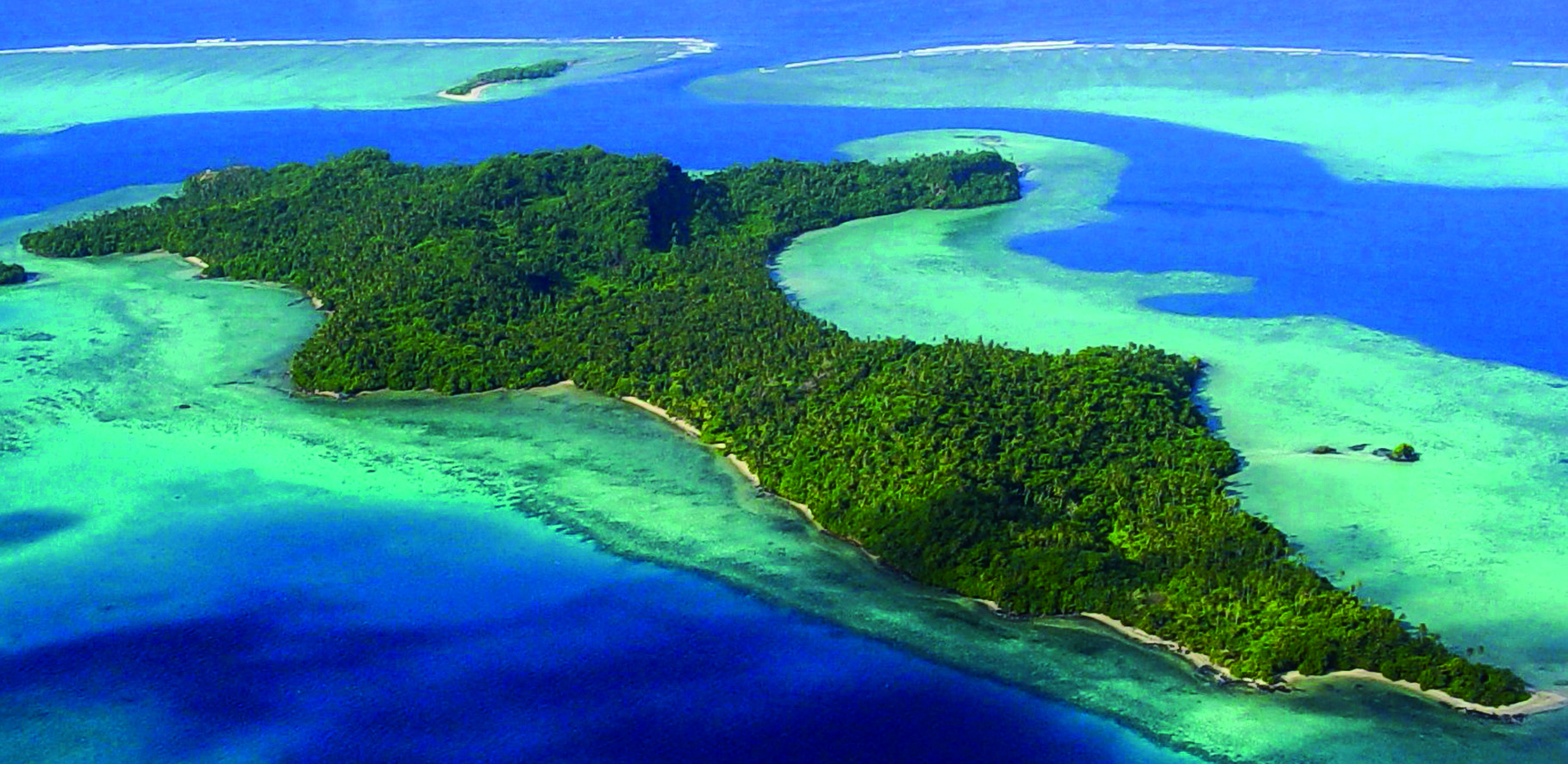
The islet of Nukuatea and Wallis coral reef, 2006 (Photo: S. Giffon).
Aerial view taken from the north, a dozen uninhabited islets and the coral reef surrounding the main island could reduce the devastating effect of tsunamis locally.

Poi village (Futuna), 2006 (Photo: S. Giffon).
View from the village church tower. A low-altitude coastal strip where traditional Polynesian houses (falé with a wooden frame and a roof made from pandanus leaves) and modern housing (breezeblock walls and sheet metal roof) exist side-by-side.
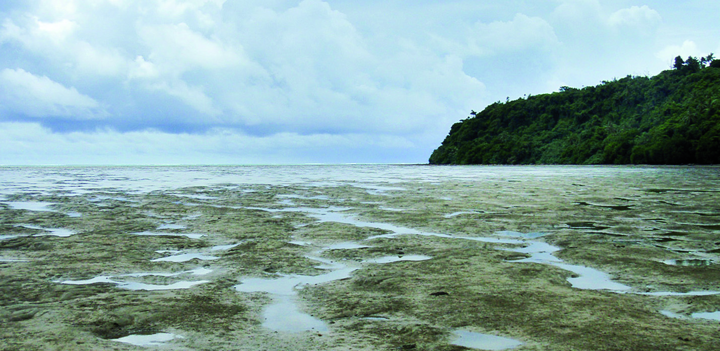
Alele beach Wallis, 2006 (Photo: S. Giffon).
On Wallis, in the northwest of the island, the coral reef flat is 3-4 km wide in places, which could help to curb a tsunami wave.


Leave A Comment