Vulnerability of Ivory Coast beaches to erosion
By Célestin HAUHOUOT, Philibert KOFFI, Patrick POTTIER
L’Atlas Bleu / Living
Ivory Coast, coastal erosion, destroyed building, precariousness of the population, sector from Grand-Lahou to Assinie
After highlighting the main physical characteristics of the Ivorian coastline on a national scale and proposing a typology of the sensitivity of its coastlines to erosion, the article examines the problem of coastal hindsight according to the point of view of the vulnerability of inhabited places. Several local examples are studied, showing the scope of the damage and the growing precariousness of local populations in some areas.


Zones and hazards
The beaches of Ivory Coast are at risk from erosion, with variable spatial and temporal factors affecting their vulnerability. In Grand-Lahou and Abidjan, recession rates of 1-2 metres/year have been recorded over the last 30 years. As a general rule, the swell is low between November and January and high in May and June, which is also the rainy season on the coast and a time when the wave force is potentially very powerful.
Causes of erosion
The end of the last sea level rise caused a fall in the high volumes of sediment deposited on beaches from the continental plateau. Present-day depositions are therefore limited to the direct products of mainland and marine erosion, leading to a shortage of sediments that has destabilised the beaches.
Beach erosion is usually the consequence of several factors. In Port-Bouët, it is exacerbated by sea defences on the Vridi Canal interrupting coastal drift further up the coast. In addition, a submarine canyon (Trou Sans Fond, isobath 100-650 m from the beach) directly adjacent to the beach traps some of the sediment transported towards the open sea by cross currents. Displaced sediment accumulated at the head of the canyon has thus carried away part of the beach on four occasions between 1905 and 1959 (Tastet et al., 1985). Furthermore, in storm conditions, pounding waves can cause the beach to abruptly recede by several metres (3-6 m or even 10 m depending on the location, with recurring events).
An increasing vulnerability to the risk of beach erosion
Recent decades have seen significant human migration to the coast, which has led to rapid and extensive urban development. Today, 30% of Ivory Coast’s population lives by the sea (Anoh & Pottier, 2008). Occupation and use of coastal spaces has not always taken the fragile nature of these environments and the associated risks into consideration. Over the years, major economic investment (ports, industrial estates, etc.) and population densification have exacerbated vulnerability to the risks of erosion. This vulnerability has been embedded in collective memory by erosion-related disasters in 1984, 1986, 2007 and 2011.
The poor are most vulnerable and the tourist industry severely affected
In Port-Bouët, in August 2007, some 30 houses were destroyed, resulting in around 100 victims and several million West African CFA francs of material damage. The majority of people affected lived in severely deprived circumstances and lost everything when their houses were swept away. In August 2011, surges washed some of the road and tourist infrastructure in Grand-Bassam and Assinie into the sea. The financial impact in Grand-Bassam came to a total of 250 million francs (€380,000) for direct damage and 150 million francs (€230,000) for loss of business, with 2000 jobs put at risk. In both cases the extent of the damage could be explained by dense and uncontrolled occupancy of the sea front and back shore.
Climate change and rising sea levels
Estimates published by the IPCC (AR5) point to a probable rise in sea levels of 52 to 98cm by 2100. When combined with the effects of storms and heavy swells, this increase is likely to intensify coastal hazards, particularly in relation to erosion in Ivory Coast.
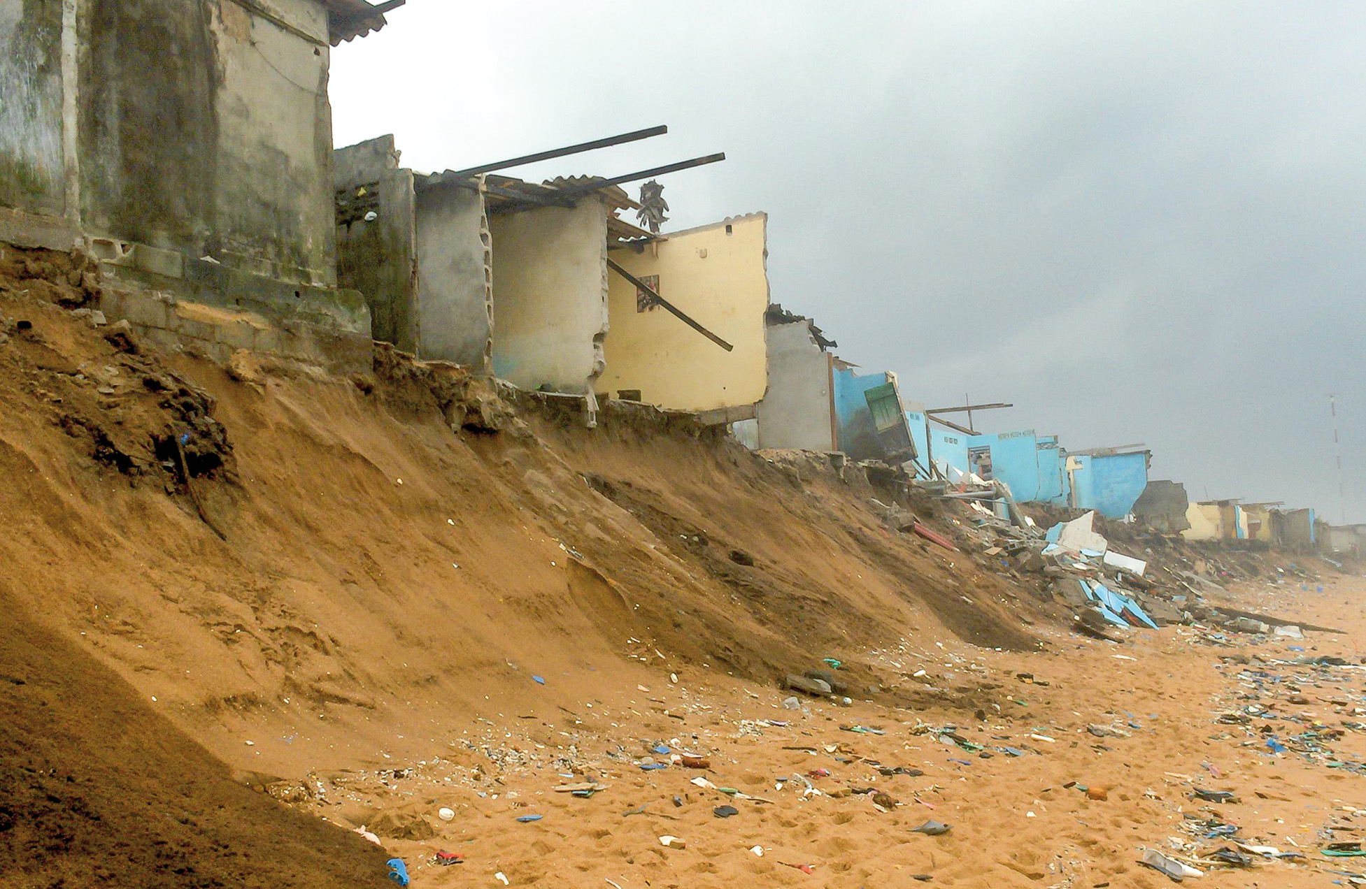
A precarious district in Port-Bouët, partially destroyed by heavy swell. (Photo: C. Hauhouot)
On the night of 13 to 14 August 2007, the coastline of Ivory Coast was submerged by a devastating storm surge.
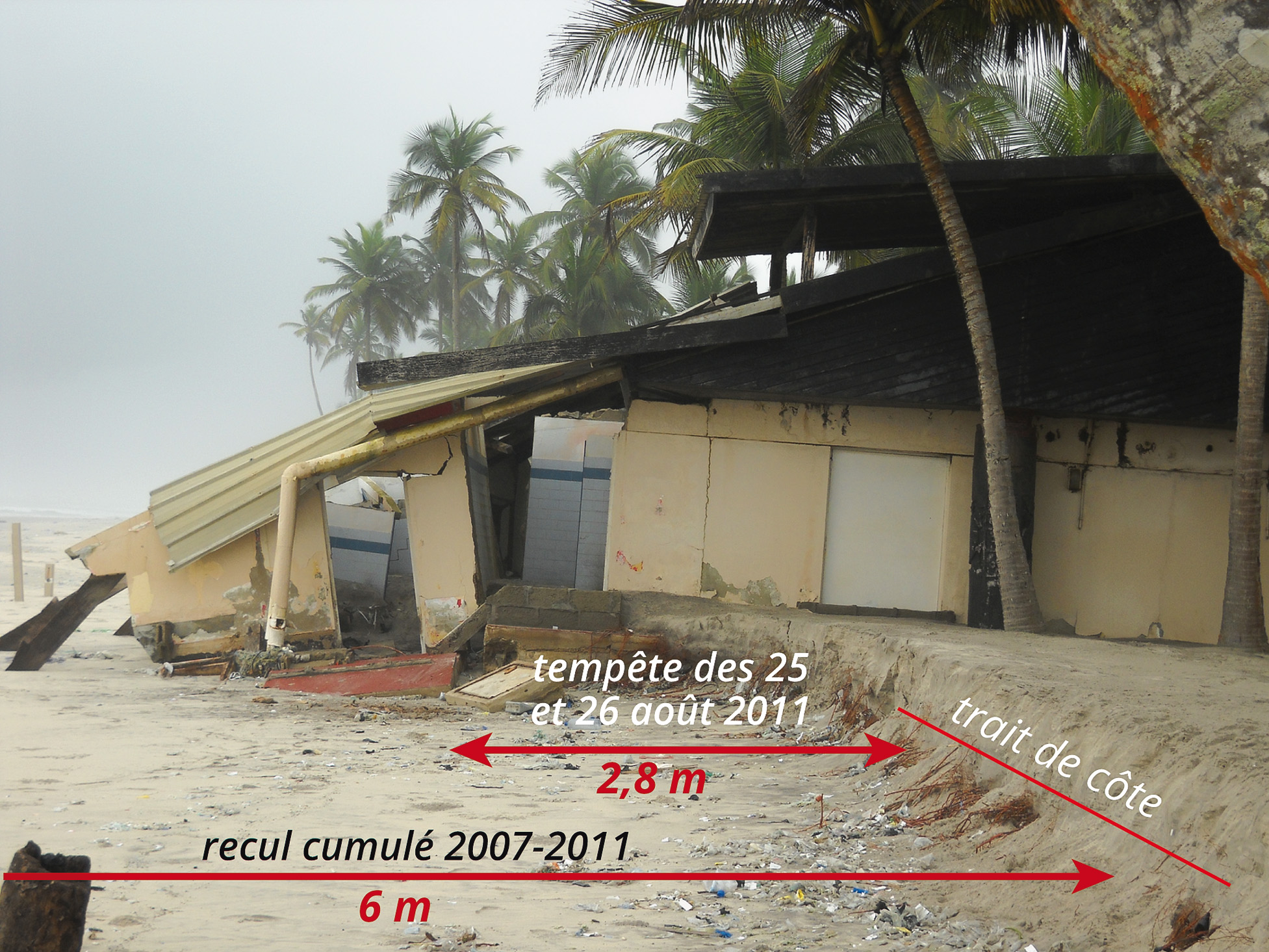
The destroyed Valtur d’Assinie tourist complex. (Photo: K. Ph. Koffi)
The storm surges of 25 and 26 August 2011 had a rapid and severe impact, as significant and noticeable recession of the beach (3-6 m) led to the destruction of coastal homes and infrastructures.
The example of the erosion of the Grand-Lahou sandbar

Erosion of the Grand-Lahou sandbar. Oblique aerial photograph D. Roelvink (UNESCO-IHE) 30 November 2011, BD num. Occ. sols CCT/BNETD 1/5 000, image Spot panchro. 2004
The Grand-Lahou sandbar has formed in an area lacking in sand. This shortage is offset by erosion from sand ridges as deposits from rivers are presently negligible. However, lateral migration (east-west) from the Tagba Lagoon inlet, which is fed by the Bandama river, is also a cause of erosion, which, although more subtle, is more significant. Indeed, the population perceives it to be the greatest risk facing the village because it causes destructive erosion. Since 1993, lateral migration from the inlet has destroyed 765 metres of the offshore bar. The losses are enormous, as the area’s buildings, dating from this historic town’s period of prosperity in the 19th century, have quite literally been destroyed. The few remaining are being washed, one-by-one, into the water. This has already happened to the lighthouse and the Auberge de Cap-Lahou, from where tourists would once admire the view of the waters meeting in the river mouth.


Leave A Comment