
The most densely populated coastal areas of the planet in 2015
The most densely populated coastal areas of the planet in 2015 By Jacques GUILLAUME L'Atlas Bleu / Living Coastal population density, deadly disaster, vulnerability The article provides a cartographic inventory of major coastal urban agglomerations and their geographical distribution on a global scale. It discusses the challenges posed in terms of exposure to risks in these densely populated areas, where varying societal characteristics add to the demographic density, varying from one place to another. In Asia, although the monsoon
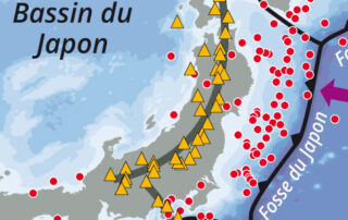
Japan: an example of an archipelago at high seismic risk
Japan: an example of an archipelago at high seismic risk By Jacques Guillaume L'Atlas Bleu / Preventing Earthquake, tsunami, population, deadly disaster, Japanese archipelago. This article presents a cartography of the main structural elements placing Japan in an intense seismic zone. It compares the population density of the archipelago with the inventory of earthquakes which occur over the 20th century. These elements show the vulnerability of this area. The example of the earthquake of march 11, 2011, reminds the chain of catastrophic events that led to the major nuclear accident in