
Maritime safety in the Channel and the Bay of Biscay and the loss of merchant ships
Maritime safety in the Channel and the Bay of Biscay and the loss of merchant ships By Éric LE GENTIL L'Atlas Bleu / Preventing Maritime traffic, security, prevention, merchant ship, Channel and Bay of Biscay. The article presents an inventory and a typology of the means used to fight against the shipping accidents in the English Channel and the Bay of Biscay, two important places of the global maritime traffic. A map summarizes the spatial articulation of the system set up both at sea and on land. The documents look at

Tsunami vulnerability assessment for Wallis and Futuna and protecting populated areas
Based on the physical characteristics of the Wallis and Futuna Islands, this article expose the risk factors of each islands according to the exposure of the populations and proposes a synthetic zoning map of their territories according to the degree of global vulnerability. The solutions emanating from the local authorities to alert the inhabited areas are visuealized and compared.
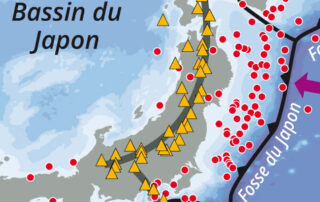
Japan: an example of an archipelago at high seismic risk
Japan: an example of an archipelago at high seismic risk By Jacques Guillaume L'Atlas Bleu / Preventing Earthquake, tsunami, population, deadly disaster, Japanese archipelago. This article presents a cartography of the main structural elements placing Japan in an intense seismic zone. It compares the population density of the archipelago with the inventory of earthquakes which occur over the 20th century. These elements show the vulnerability of this area. The example of the earthquake of march 11, 2011, reminds the chain of catastrophic events that led to the major nuclear accident in

Piracy worldwide and its recent developments (1985-2012). The case of Africa
Piracy worldwide and its recent developments (1985-2012). The case of Africa By François GUIZIOU et Daenis OTSA'A NGUEMA L'Atlas Bleu / Preventing Maritime piracy, evolution, spatial characteristic, Gulf of Guinea, Gulf of Aden, Africa Through maps and graphs, the article presents the world geographical context of maritime piracy and its recent evolution. Maritime piracy has been geographically refocused on the African “shores”. Then, it examines in details the piracy occurred on the coasts and seas of the African zones concerned by this phenomenon (Gulf of Guinea and Gulf of Aden), by
Distribution of major naval forces worldwide
Distribution of major naval forces worldwide By Jacques GUILLAUME L'Atlas Bleu / Preventing Naval force, strategic base, ranking of States, world In this article, the inventory and spatial distribution of the strategic bases of the world’s main naval forces and the ranking of the top 15 oceanic military powers provide insights into the strategies of the States in terms of political influence on the blue planet. Spatial distribution of the strategic bases of the world’s main naval forces (interactive map)