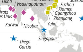
Distribution of major naval forces worldwide
Distribution of major naval forces worldwide By Jacques GUILLAUME L'Atlas Bleu / Preventing Naval force, strategic base, ranking of States, world In this article, the inventory and spatial distribution of the strategic bases of the world’s main naval forces and the ranking of the top 15 oceanic military powers provide insights into the strategies of the States in terms of political influence on the blue planet. Spatial distribution of the strategic bases of the world’s main naval forces (interactive map)

Fishing resources: catches and food availability
Fishing resources: catches and food availability By Julien NOËL L'Atlas Bleu / Exploiting Fishery resources, fishery, food fish consumption, disparity, world A map established on a global scale allows to compare the per capita food fish consumption by country and the fisheries catches of the adjacent ocean areas. North-South and inter-continental global disparities are highlighted and commented, revealing deep global imbalances in access to fishery resources. Fishery catches by FAO area and seafood food availability by country (interactive map)